Best GPS RTK Base Station Picks for Precise Field Surveying
Answer: For those seeking reliable real-time kinematic (RTK) base stations, these five options provide strong centimeter-level accuracy, wide GNSS support, and practical field usability. They’re best suited for professional land surveying, drone mapping, construction stakeouts, and GIS work. Read on to compare capabilities, ideal use cases, and practical buying notes. A compact summary of the chosen products is provided below to help quick decision-making.
| Product | Best For | Key Benefit |
|---|---|---|
| SingularXYZ E1 GNSS RTK Base Station | Field engineers and survey crews needing compact base station | Fast fixed positioning in challenging environments |
| SingularXYZ E1 Lite RTK Base Station | Budget-conscious professionals | Full-constellation GNSS with quick solutions |
| SMA26 Pro RTK GNSS Surveying Equipment | Versatile sites with mixed RTK brands | Wide compatibility and PPP/PPK options |
| SMA20 Pro RTK Base Station | Advanced projects requiring tilt/IMU support | High channel count with IMU and NOAA features |
| SMA20 Base Station | Long-duration base operations | 1 cm RTK/0.25 cm static potential with dual modes |
SingularXYZ E1 GNSS RTK Base Station

The E1 is designed for rapid, stable positioning in demanding environments, including multipath, tree canopy, and urban canyons. Best for field crews needing a compact, lightweight base station without compromising performance. It weighs about 870 g and measures roughly Φ133.5 mm × 67 mm, making it easy to transport between sites. A Type-C port supports fast charging, delivering up to 20 hours of continuous operation per charge.
Who it’s best for: Survey teams that require quick setup, portability, and long runtimes in tough environments. Limitations: Battery life may vary with duty cycle and environmental conditions; verify field power needs for extended projects.
SingularXYZ E1 Lite RTK Base Station

The E1 Lite delivers centimeter-level accuracy with full-constellation GNSS support, making it suitable for land surveying, drone mapping, and RTK rover work. It is noted for fast fixed solutions in challenging settings, such as urban canyons and dense canopies. The device emphasizes affordability while preserving essential RTK performance.
Who it’s best for: Professionals on a budget who still need reliable fixed solutions. Limitations: May have fewer premium features or accessories compared to higher-end models; plan for compatibility with your workflow.
SMA26 Pro RTK GNSS Surveying Equipment

The SMA26 Pro is a full-constellation RTK GNSS system with 4G communication and wide protocol compatibility. It includes a rover and base pair plus an Android device with surveying software. It supports PPP, PPK, RTK, and CORS network base configurations, enabling versatile deployment for diverse surveying tasks. It claims centimeter-level RTK accuracy and 2.5 cm tilt accuracy, useful for difficult sites.
Who it’s best for: Projects requiring cross-brand compatibility and multiple operating modes. Limitations: Setup and integration may be more complex due to broader feature set.
SingularXYZ Universal Tribrach/Base
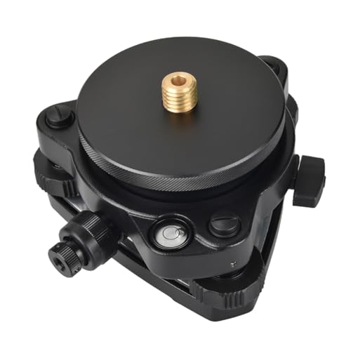
This tribrach/base provides universal compatibility for GPS RTK, total station prisms, and tribrach adapters. It emphasizes adjustable leveling and durable aluminum construction. Best for field teams that need a robust, versatile base accessory to ensure stable measurements across different instruments. It is not a standalone base station; use it to upgrade current setups.
Who it’s best for: Teams with multiple instruments requiring a common base for stability. Limitations: Not a standalone RTK base; relies on paired GNSS hardware.
Waveshare LC29H Dual-Band GPS Module

The Waveshare LC29H module supports dual-band L1 and L5 and can establish an RTK base to transmit corrections. It is designed for Raspberry Pi and similar platforms, offering GNSS raw data output for RTK workflows. Best for tinkering setups, pilots, or field labs that need a compact base-capable module with computer integration.
Who it’s best for: DIY or educational projects, and developers building custom RTK bases. Limitations: Requires integration work and compatible host hardware; not a ready-to-use rugged base station on its own.
Buying Guide
- Core performance: Look for centimeter-level RTK accuracy, robust fixed-solution speed, and full-constellation GNSS support (GPS, GLONASS, Galileo, BeiDou).
- Compatibility: If you already use other RTK equipment, prefer models with wide protocol support and easy cross-brand interoperability (PPK, PPP, CORS options).
- Environment and durability: Consider rugged housings, weather sealing, and battery life suitable for field days. Ultra-portable bases are great, but verify endurance under your typical use cycle.
- Power and connectivity: USB-C or integrated long-life batteries help with remote sites. Check NTRIP, 4G, and Bluetooth compatibility for real-time corrections and rover communication.
- Accessories and setup: A stable tribrach, tripod, and monopod options can impact setup time and measurement stability. Ensure availability of necessary mounting adapters.
- Cost vs. value: A higher upfront price can be justified by reliability and ease of use in critical projects. Weigh ongoing software needs and support when budgeting.
- Use-case guidance: Choose compact, lightweight bases for portable field crews; choose feature-rich bases with IMU or tilt support for complex terrains or tilt-sensitive tasks.
Frequently Asked Questions
- What is an RTK base station used for? It provides correction data to rovers to achieve centimeter-level positioning accuracy in real time.
- Do I need PPP or PPK to supplement RTK? PPP and PPK are alternative methods when real-time corrections aren’t available; RTK generally offers the fastest, most precise field results.
- Can these bases work with drones? Yes, many RTK bases are designed to integrate with RTK-enabled drones for precise mapping and surveying.
- Is a higher channel count better? A higher tracking channel count can improve satellite reception in challenging environments and support more constellations.
- What should I consider for long field sessions? Battery life, charge options, and rugged housing are critical for uninterrupted operation.
- Do these bases require subscription services? Some models offer optional network services; many provide core functionality without recurring fees.